Our third day in Iceland was definitely our longest day but we saw some amazing things!

As you head south out of Reykjavik, you quickly leave the city and immediately come across land that looks like this. Gray, drizzly, unknown fauna type.

It feels like some other planet, but the views are often incredible.

The Ring Road (aka: Route 1) runs in a giant circle around Iceland. Some people have more than 7 days to spend and don't have kids with them so they drive the entirety of it. I wouldn't mind doing that someday! The Ring Road is a nice road - I'm not even sure we ever came across one pothole! (COUGH COUGH Massachusetts!) Once you get off of the Ring Road, it's very possible the road will not be as well maintained, so some people book tours with vehicles that CAN drive on the rocky, muddy back roads.

Our first stop was Seljalandsfoss. This is one of Iceland's most famous waterfalls, perhaps because you can see it directly from the Ring Road and because it stands about 200 feet tall.

That's, uh... an interesting sticker collection you've got there Seljalandsfoss!

As we got out of the car, Grant noticed there were two sheep WAY up high on the mountain in the form of two little white dots. How did they get there? How will they get down? Clearly they have done this before!

Seljalandsfoss doesn't really have a translation, except for that it's the "Seljalands Waterfall." "Foss" means waterfall in Icelandic.

Curiously, these cliffs represent the former shoreline of Iceland!

Anyone can walk the path behind Seljalandsfoss waterfall (grrr - I get mad everytime I write that because I'm essentially writing, "Seljalands waterfall waterfall.") There is a nice walking path that goes from one side to the other, but be prepared to get wet!

The water that you see here has its source within the Eyjafjallajökull Glacier (which sits above the volcano that famously erupted in 2010 and disrupted a bunch of air traffic to and from Europe.) That volcano and glacier are about 20 kilometers to the east of here.

My little buddy was excited and wanted to walk behind the waterfall! He's dressed for it!

Bailey family selfie in front of Seljalandsfoss! Todd had a nice capture of the waterfall right between Natalie and Grant!

There's not a ton of greenery in Iceland due to the harsh climate, but I managed to find some pretty purple flowers.

I'm sure this is fine, right?

Floodplain alert! I need someone to run a HEC-RAS model on this river for when the volcano blows and melts the glacier so much that all of the water comes screaming down the waterfall. What are the hydraulics on those bridges? Oh my word, I'm such a nerd!
This used to flow directly to the Atlantic, but now it flows into some lowlands before reaching the sea.

If I had several more weeks, I would definitely go off the beaten path more and hit up some of the other waterfalls. I feel like you could spend months here and still not see it all.

It depends on the wind of course, but you're gonna get wet behind this waterfall.

Todd and Grant decided to take the plunge (I'm so punny!) and walk behind Seljalandsfoss. It didn't look like a particularly tough walk, but Natalie and I just didn't want to get wet!

I spy Todd and Grant - the two humans who are on the left. Todd is wearing a gray jacket and Grant has the hood up on his light gray and blue waterproof jacket.

I'm glad they went so they could take all the cool pictures for the blog, and I stayed dry!

My boys took a selfie with the waterfall roaring behind them. They're already soaked!

What an amazing view!

Grant, is that you???

The hubs really knows how to take a nice panorama picture! Justin Bieber himself liked this area so much, he shot his, "I'll Show You" video here (at least partially - more on that to come!)

As we went back to the car, we noticed our friends (the sheep) making their way slowly down the mountain!

Soon, it was back in the car and back on the road heading south. From the Ring Road, you can see Eyjafjallajökull volcano and it's glacier.
All of us in the car: Is that a glacier over there? It looks like a glacier!
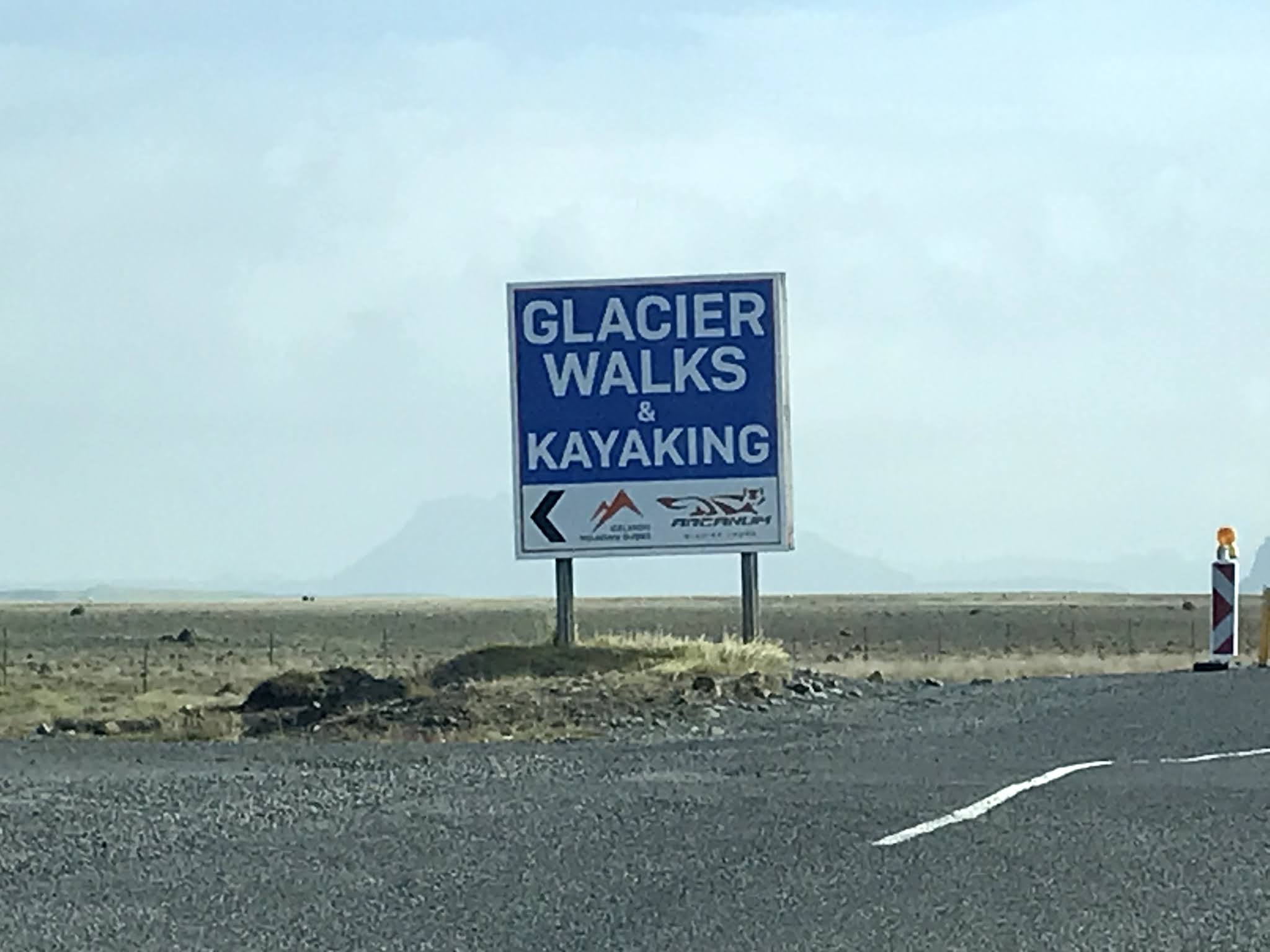
This sign: YEP!

Our next stop for the day's adventures was Dyrhólaey peninsula. This was the farthest point south that we traveled.

And boy was it worth it! In the distance, you can see the black sea stacks known as Reynisdrangar.

Bailey family selfie at the Dyrhólaey peninsula with Reynisfjara beach and Reynisdrangar basalt sea stacks behind us, above the poof in Natalie's hat.

This was my very favorite moment of the day! Only between the months of May and August can you see the Atlantic puffin around Iceland as this is their breeding season. Over half of the world's Atlantic puffins live here!

Dyrhólaey is one place to see these beautiful and funny birds. There were several dozen of them lounging around in the afternoon sun.

Puffins build their nests into these high, rocky cliffs and they're one type of animal that mates for life. They also live on average for about 20-25 years.

This puffin is just enjoying the views of Reynisfjara beach.

If you go up to view the puffins, make sure you turn around because the view in the opposite direction reminds me a bit of scenes from the movie Goonies!

I'm pretty sure my babies and I are under all those hats and masks and sunglasses! Nat is proudly wearing Pop Pop's favorite binoculars so we could get a good view of the puffins as well as other sites around southern Iceland.

Alright fine Todd, you can join us too. The big rock right above Todd's head is known as Arnardrangur or "Eagle Rock." There aren't any eagles there anymore, but they used to nest there about 170 years ago.

It almost looks like a fake background behind Natalie and Grant! Is this a green screen??

This area kind of reminded me of Ireland - not just the scenery and the beauty, but also the wind!

If you visit Dyrhólaey, there are two road options to take to get here, and both are exits off of Route 208. The first of the two is the one we took - it's a public paved road that will not require 4WD. Route 218 basically ends in the parking lot of the viewpoint we visited. The other option is to take the first right off 218 after the long bridge- but this will definitely require a car with 4WD! That road takes you up to a higher viewpoint which has a beautiful lighthouse just out of view on the cliffs on the right.

The good news is that you can also hike between the two, but we didn't have time for that. That's ok - because the views at the lower viewpoint are awesome!

Everyone assumed this tree was like, a billion years old and so they felt the need to walk across it.

We headed back north after bidding the puffins goodbye, and we saw this great turf house built into the side of the hill just off of route 218.

As we continued to head north a bit, you can also see Sólheimajökull glacier, which is a smaller glacier on the larger Mýrdalsjökull ice cap. This sits just to the east of Eyjafjallajökull, so don't blink because sometimes it's hard to tell the difference. This particular glacier inches the closest to the Ring Road.

Our next stop of the day was to the Sólheimasandur Plane Wreck, where a US Navy DC-3 crashed in November of 1973 on the black sandy beach. The endless rocky "road" to the plane takes about an hour to walk, one way. You used to be able to drive your car down this road but it got too touristy so they built a car park near Route 1 and now it's necessary to walk to the plane. There is also apparently a shuttle bus that you can pay a few bucks for but we never saw any signs of that, despite the fact that it's the high season for tourism in Iceland. Must be a Covid thing.

About 3 minutes into the walk, Natalie realized she had forgotten her mask, so she and Todd ran back to the car to get it. Meanwhile, Grant and I were pretending to be Lego people.

When I say that we encountered very few people, I'm definitely not exaggerating. The Bailey's had a beautiful day and a relatively easy hike, but in October of 2017, an American tourist died of exposure because of the sudden change in the weather here. It's very easy to lose sight of the "road" in poor conditions and the yellow markers you see ahead are only posted every 50 meters.

How it started.

How it's going.
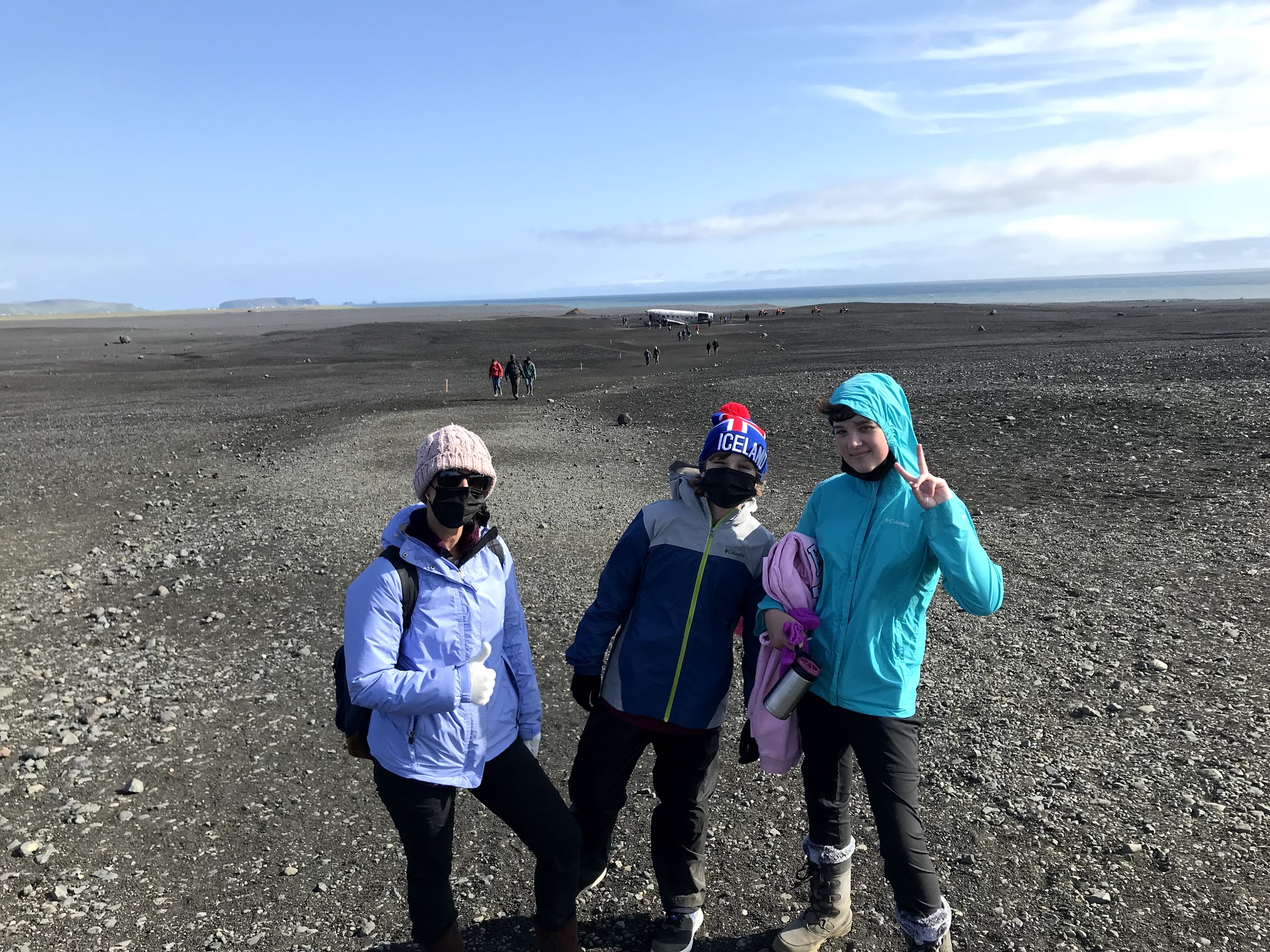
Natalie eventually caught up to us and after hiking for a good hour, we finally spotted the plane!

The story behind this plane is that the pilot of this DC-3 ran out of fuel during a storm... although it's believed that the reason the plane ran out of fuel is because the pilot switched to the wrong fuel tank!

The plane was obviously stripped of all of the important pieces (by the US military), but otherwise was just left here on the beach.
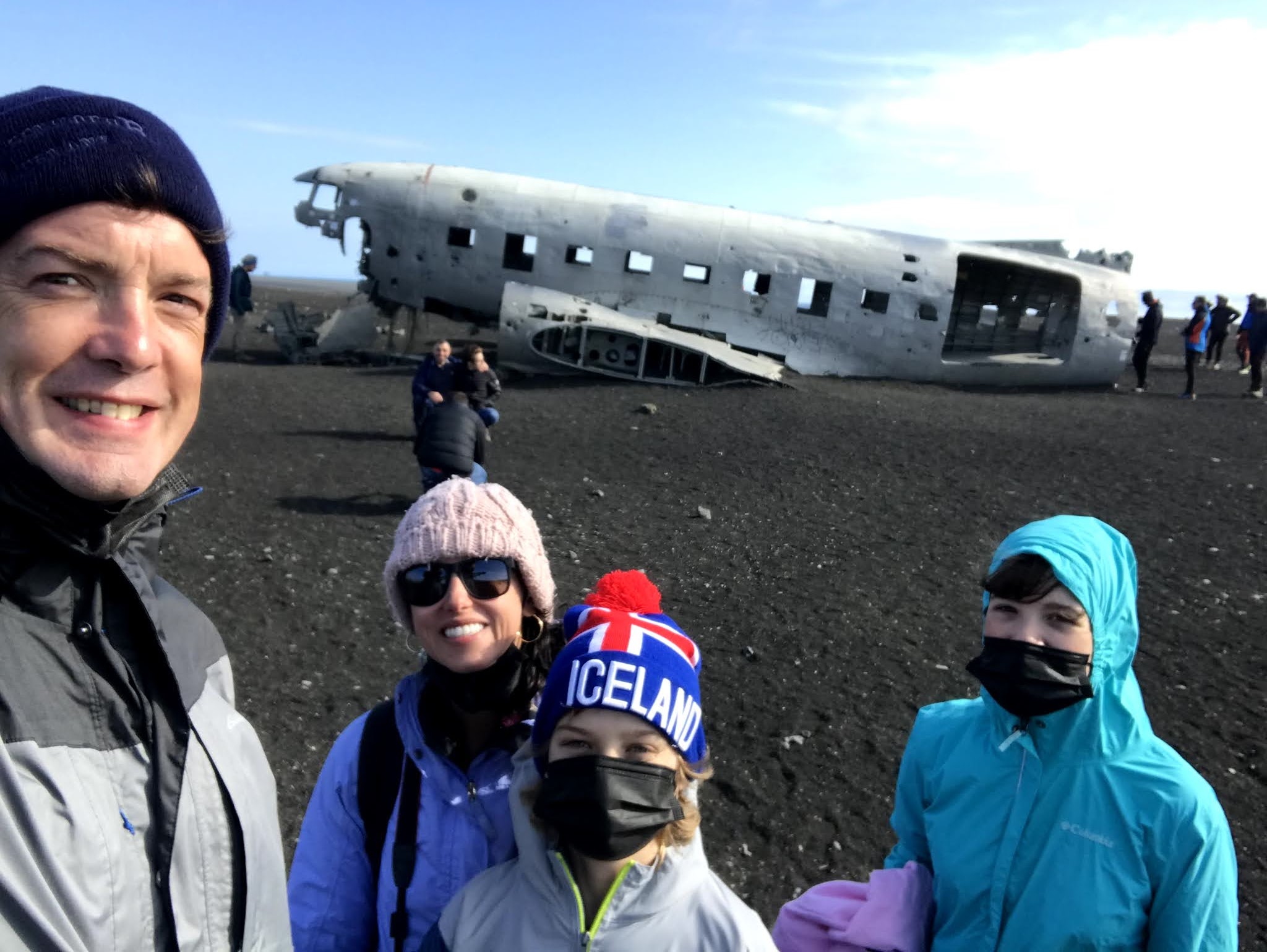
Bailey family selfie at the Sólheimasandur plane wreck.

Grant immediately did some exploring around the plane. They tell you not to climb on the plane but people largely ignore this.

Grant in the fuselage of the Sólheimasandur plane wreck. In case you're wondering about the crew of this aircraft - they all survived and only waited about an hour for a Naval helicopter to arrive from Keflavik to rescue them. The US military decided not to recover the aircraft because at the time, the Ring Road was not complete and this was a very difficult location to get to.

Natalie really wanted to come see this plane wreck more than anyone in the family because one of her favorite K-Pop girl group singers, HaSeul filmed a solo video here. (Side note: So did Justin Bieber in his video "I'll Show You!")

This is HaSeul (from Loona) in her video for "Let Me In." And here's Natalie, in the exact same spot!

This was fun to do - she was really excited to visit the same spot as a member of one of her favorite bands!

Grant, do you want to pretend you're in a K-Pop girl group video, too? Sure, dude!

Todd always takes a nice panorama! This is facing northeast from the Sólheimasandur plane wreck. Iceland or the moon, you decide!

This was a super cool picture Todd took of the kids in the plane wreck.

Will the passenger in seat 6A please put his seatbelt back on?

Todd being Todd in front of the Sólheimasandur plane wreck. Again - there were maybe 15 other people there - plus one dog!

Apparently when we left though, everyone else decided to also leave. You can see how remote this location is and the Dyrhólaey peninsula is off in the distance, above our heads.

Almost everything in Iceland is in both Icelandic and English. Rarely are there other languages presented - except here, where the safety rules were also shown in Chinese!

Todd drove to our next destination, so I was able to take pictures out the passenger side window of the car. This river comes directly out of the Solheimajokull glacier.

Well, you know I'm gonna take as many pictures of floodplains as I can.

You can see Solheimajokull glacier in the distance. I bet that water is cold!

Finally, we arrived at our final destination of the day - Skógafoss Waterfall. This waterfall descends from the Skóga River, which you can see here.

This is another waterfall you can see from Route 1. It might be even MORE majestic!

Skógafoss is one of the most well known waterfalls in all of Iceland. In fact, they filmed scenes here in Game of Thrones, Thor: Dark World, and our new favorite - the Vikings series from the History Channel! (Note: Not a new show. Just something new we started literally here in Iceland!) You can climb the (around 500) stairs to the top - as you can see on the right side of this picture - but we were already at about 17,000 steps for the day and I don't think any of us could have done that!

Skógafoss is about 80 feet wide by 200 feet tall, and it, like many other waterfalls in this area, marks where the Icelandic coastline used to be.

If there is any sun on the day you visit Skógafoss, there WILL be a rainbow. This rainbow leads to my pot of gold!

Squiggles von Squiggletron and her dad staying dry at Skógafoss.

That's a serious amount of water! And it all comes from BOTH Eyjafjallajökull and Myrdalsjokull!

Errr, I, uh.... I don't know what Todd found here! Human or animal, you decide!

Look, I found a rainbow and like 8 other people! Who all felt the need to be in my picture, including Natalie ha!

Alas, we were exhausted and it was time to head back to Reykjavik. But not before a few more shots of Eyjafjallajökull! Did you know that Eyjafjallajökull is only about 5500 feet high?

Wait, did you put a boat here in the side of a mountain? Perhaps this was to signify that this was the former coastline of Iceland!
When the sun comes out... wow. It feels like you're in Lord of the Rings or something!

All along the south coast, there are various waterfalls. We stopped to see some of the more famous and impressive of the falls, but there are plenty to see, even just from Route 1!

Throughout this entire trip, I would see houses (?) like this and say, "That's where I'm gonna live when I retire!" Away from the rest of the world!

Todd was still suffering from jet lag, so I made him pull over so I could take over driving duties (and hope that my new favorite song, "10 Years" by Daði Freyr would come on the radio!) So when we stopped, we spotted this puffin statue welcoming us to Vestmannaeyjar, which means, "Westman Islands." It consists of the islands off the coast, but the road on which this little cute statue sits leads you to the ferry that takes you to the islands.

We didn't get to the Vestmannaeyjar but I definitely want to get there at some point because it's home to the "loneliest house in the world" and you know I want to see that superlative! Next time, Westman Islands!

The jet lag was hitting everyone (but me?) hard on this day. He still looks so cute when he sleeps!
Until next time, southern coast of Iceland!
No comments:
Post a Comment